Deviation Actions


Description
This is a map of what could have made Versailles far *less* of a poison pill had the Allies implemented the Treaty as follows (scroll further for backup and rationale so far):
Companion detail maps (so far):
Alternate Versailles 1935 - Germany
Alternate Versailles 1935 - Corridor
Defensible Czecholslovakian Concessions
Alternate Versailles 1935 - Poland
Alternate Versailles 1935 - Greater Hungary
Goal: a stable postwar European order in which:
(i) grounds for German and Hungarian irredentism are minimized;
(ii) Germany is better incentivized to pursue constructive policies
concerning her neighbors;
(iii) national borders are generally defensible;
(iv) liberal democracy generally prevails in Central Europe.
Provisions:
(a) Alsace-Lorraine is ceded to France per the original timeline.
(b) The Rhineland is demilitarized per the original timeline.
(c) The Saarland is placed under probationary French administration
pending 1935 reunification referendum per the original timeline.
(d) The size of the German military and equipment permitted it is
restricted per the original timeline.
(e) Substitution of an Occupier's Liability clause for the War Guilt clause
allows total German reparations to be reduced to an amount closer to
the cost of physical reconstruction, and a loan mechanism for their
fulfillment along the lines of the Young Plan, to take effect by 1922,
is stipulated.
(f) Germany is admitted to League of Nations by 1924.
(g) The Eupen-Malmedy territories are ceded to Belgium, but may be
repurchased after 1930, subject to League approval (2/3 majority
member vote).
(h) Estonia, Finland, and Latvia gain independence, with all borders
matching the original timeline with the exception of those stipulated
for Poland (see item [p]).
(i) Anti-Bolshevik Allied expeditions in Russia remain concentrated within
the Baltic States, Belarus, and Ukraine, and their presence sustained to
establish of both as Allied client states, replacing Poland as the lynchpin
of the “cordon sanitaire” buffering Europe from Soviet influence or
invasion, and reducing Warsaw’s bargaining power and militarism
accordingly, with a similar effect vis a vis Romania.
(j) The German-Polish frontier is generally drawn with greater care to match
ethnic majorities, provided:
(i) transport is not disrupted;
(ii) the border follows natural courses defined by the local terrain;
(iii) frontiers for Upper Silesia and Masuria are drawn on the same basis
and imposed *without* the bungled plebiscites;
(iv) Bromberg and environs ceded to Poland per the original timeline.
(k) Danzig is placed under probationary Polish administration pending a
1932 reunification referendum, subject to League approval (2/3 majority
member vote), under terms similar to that of the Saarland.
(l) Germany retains portions of prewar Kreise of Putzig and Neustadt
adjoining Danzig’s western border, allowing for restored German territorial
contiguity following a favorable referendum result in Danzig.
(m) Guaranteed Polish sea access retains its original interpretation as
internationalization of the Vistula, and entails:
(i) the waterway and both fortified riverbanks placed under permanent
League of Nations protection;
(ii) at German expense, roads and railways constructed on both
riverbanks, and fortified in turn on each side by “canyon walls” 300
meters in height that descend from the apex of a concrete ramp 500
meters in width with endpoints at Danzig’s southern frontier and the
Vistula Delta;
(iii) one large overhead road and rail structure is permitted to bridge the
fortifications;
(iv) the Bohnsack/Sobieszewo delta island is ceded to Poland for future
port construction.
(n) East Prussia is demilitarized west of the Passarge River.
(o) Pomerania/Weimar West Prussia is demilitarized east of the Wipper River.
(p) Poland’s Eastern frontiers are fully demarcated at the Conference such that:
(i) they follow a refined Curzon-B line that is more ethnically
representative, reasonably defensible, and minimally disruptive of
transport and local economic networks;
(ii) ethnically Polish areas of the northern Kresy, including Wilno, are
similarly incorporated, with Lithuania under Allied pressure to offer no
resistance to Poland;
(iii) they are stabilized by the Allied presence in the new Eastern client
states, including the Baltic States.
(q) An earlier British delegation proposal for Sudetenland is adopted, allowing
for:
(i) smaller yet highly significant areas (e.g. Karlsbad, Reichenberg) to be
awarded to Germany or Austria;
(ii) preservation of a naturally defensible Czechoslovakian frontier.
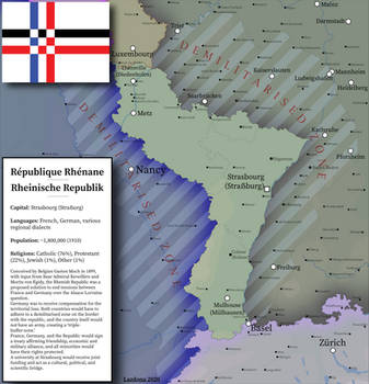
(r) Austria is guaranteed a reunification referendum no later than 1935,
subject to League approval (2/3 majority member vote), following a secret
Treaty between France, the Netherlands, the UK, and Germany that provides
for:
(i) French annexation of Wallonia by 1930;
(ii) generous German funding for a Flemish separatist campaign resulting
in incorporation into the Netherlands.
(s) Austria retains the German-speaking northernmost third of South Tyrol.
(t) Hungary retains small but important ethnically Hungarian borderlands to the
North, East, and South, without disrupting transport in Slovakia, Romania, or
Yugoslavia.
(u) The Romanian border is drawn with greater care to match ethnic majorities, to
the relative advantage over the original timeline of Ukraine and Bulgaria.
(v) The Ukrainian-Belarusian frontier is drawn along reasonably defensible ethnic
lines.
(w) Russia’s western frontier is drawn by the Allies following highly defensible
geographic features lying between the maximum original timeline advances of
the Whites and the Poles, respectively.
(x) Transylvania, intractably irreconcilable on ethnic grounds to any neighboring
nation-state, is established as a Swiss-style, multi-ethnic state, and is granted:
(i) international tariff exemptions for its exports;
(ii) exemption from controls or taxation by other League members for
incoming foreign investment.
(y) Macedonia is guaranteed a referendum over joining Bulgaria by 1925.
(z) Other minor border corrections are implemented.
Note 1: Balkan conflicts could still occur, but with Russia no longer entangled as in 1914, their impact would not upset the general order.
Note 2: For fun, I'm also assuming a reconciliation of Ulster with Ireland, in exchange for Irish dominion status on the lines of the 1931 Statute of Westminster.
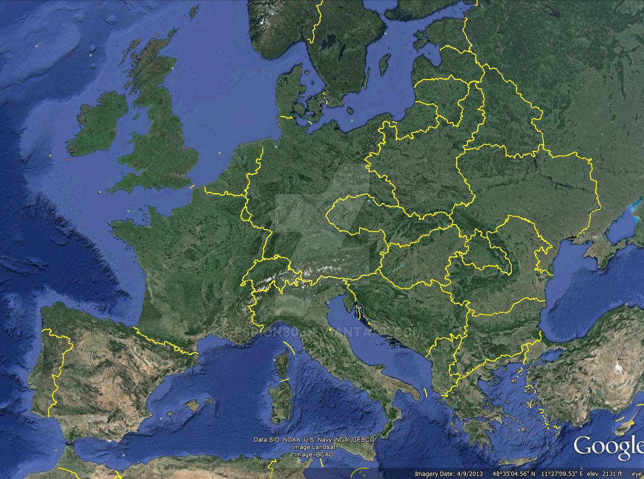
3. KEY MAP SOURCE MATERIAL LINKS
Aside from the obvious maps covering infrastructure, population density, topography/waterways, etc., here are the ethnic maps which, based on an exhaustive review of alternatives, have proven most useful in terms of both minimal bias and maximum detail:
Poland, Lithuania – Polish Ethnic Distribution, 1918
upload.wikimedia.org/wikipedia…
Silesia – Ethnic Distributions, 1906
gauss.suub.uni-bremen.de/suub/…
East Prussia – Ethnic Distributions, 1906
images31.fotki.com/v1083/photo…
Posen – Ethnic Distributions, 1896
freepages.genealogy.rootsweb.a…
West Prussia – Ethnic Distributions, 1910
upload.wikimedia.org/wikipedia…
Bohemia – German Minority, 1864
commons.wikimedia.org/wiki/Fil…
Bohemia – German Minority, 1938
s-media-cache-ak0.pinimg.com/o…
Greater Hungary – Multiethnic Character, 1880
gallica.bnf.fr/ark:/12148/btv1…
Slovakia – Persistence of Hungarian Minority, 2011
en.wikipedia.org/wiki/Hungaria…
Transylvania – Multiethnic Character, 1850
imageshack.com/f/5xerdelyminor…
Transylvania – Multiethnic Character, 1910
i.imgur.com/ERfpSyQ.jpg
Transylvania – Persistence of Multiethnic Character, 1992 vs 2002
sebok1.adatbank.transindex.ro/…
Vojvodina – Persistence of Hungarian Minority and Multiethnic Character, 1880-2002
i.imgur.com/YnTjIur.gif
Belgium – Stable Ethnic Divisions, 1920
upload.wikimedia.org/wikipedia…
Ukraine, Ruthenia, Belarus, Bessarabia – Ethnic Distributions, 1900
irbis-nbuv.gov.ua/E_lib/SHOW/0…
Ukraine, Russia – Maximum Anti-Bolshevik Control, 1919
upload.wikimedia.org/wikipedia…
Ukraine, Russia – Maximum Polish Control, 1919
upload.wikimedia.org/wikipedia…
SELF-INDULGENT RANT ON RATIONALES AND METHODS SO FAR
As we know, in the original timeline, the Big Three demarcated borders according to a set of considerations that drew only on their own territorial designs, or those advocated by Germany’s least friendly postwar neighbors. The criteria that shaped their guiding considerations were, primarily, a proposal's urgency for advancing each major Allied power’s own national self-interest, and secondarily, the degree to which a given demand could most easily deliver the *perception* of justice, in the sense that populations of concern *to the Allies* had fewer grievances over which to forment economic or even military instability. A military balance of power (in contrast to national self-defense) was the third criterion.
The defeated powers' claims, even the most valid, were of little concern in this process, as the Big Three trusted their own appraisal of what constituted an acceptable outcome for the Reich and its people. Yet fear was widespread both among the rank-and-file Allied delegates at the peace conference - and among each Allied power’s general voting public - that baldly punitive measures might lead Germans to embrace a dangerous, possibly revolutionary mass irredentism. Both George and Wilson, for their own reasons and after their own fashions, felt obliged to acknowledge this risk on multiple occasions. Yet however well-acknowledged the risks of provoking German irredentism, calls to minimize this danger were the least likely demands to ever qualify for inclusion in a Big Three consideration set guiding their final demarcation of Germany’s boundaries. Senior delegates in their charge would often airily dismiss the question as a sentimental over-complication, if not a mark of disloyalty to crown or country. Perversely, one such delegate, having just assisted the Big Three in splitting the Reich’s territory in two to make way for the Polish Corridor, even argued that disregarding the risk of German irredentism was perfectly acceptable *because* Germany’s economic might and vast territory made the nation and its people able to bear such a “minor amputation”. The fruits of such arrogance included, among others, such injured collective pride among tens of millions of educated, civilized German citizens that they were primed, once exhausted by economic depression, to find a certain sweet vengeance in Hitler’s brutal message of hatred and total domination. With that sort of arrogance to answer for, blindsiding the Belgians into partition to buy France’s blessing for an eventual Anschluss could just as well be filed under “humility”.
Apart from Alsace-Lorraine's cession to France, which was sine qua non for France, I have attempted to ground the considerations guiding delineation of these boundaries in extensive pre-1914 documentation of all border regions, covering a range of ethnic, linguistic, and other demographic concentrations (note here that state functionaries dispatched by Berlin to West Prussia, for example, are excluded); transport infrastructure, extractable resources, and heavy industry; as well as natural features such as topography and waterways that provide for boundaries that both better conform to the landscape, and wherever possible, provide natural frontiers.
The borders also reflect my best effort to systematically identify key considerations necessary for the stable division of national territories. To help ensure that these guiding considerations are of any use, I have attempted to compile all territorial demands put forward in 1919, whether by the Allies, by other neighboring states, or by the Germans themselves, and to judge the broader strategic implications of each demand according to three basic criteria. The first criterion is the political urgency of the demand for establishing a stable postwar order firmly rooted in liberal democracy. The second criterion is the material benefit of the demand to any affected populations. The third criterion is the military defensibility of the demand's resulting borders, given the local terrain. The extent to which a given demand satisfied these three criteria determined its merit as a guiding consideration. In the admittedly frequent instances where no demand meaningfully satisfied all three criteria, I have attempted to devise a solution that does.
My assumption is that that the consideration sets guiding the revised treaty’s borders here are more advantageous, in that they allow the occasional demand expressed by Germans to qualify as a key consideration when demarcating borders. As such, demands to mitigate the very real risks of German irredentism, obvious enough in 1919, have been able to function as an important consideration when necessary at certain points in the process.
Even so, trade-offs remain between (a) equal, adequate national dignity sufficient to keep a liberal democracy stable; (b) freedom from fear of foreign invasion; and (c) minimal (if to some degree inevitable) disruption to everyday social and economic activity for all Europeans. If (a), (b), and (c) each could be scored from 1 (catastrophe) to 10 (perfection), no practical balance in 1919 could possibly achieve a score of 10 for (a), (b), OR (c) by themselves, let alone in combination. I think the original treaty was something like (a)=4, (b)=7, and (c)=6, giving a "chance for peace" score of 17/30 (57%, an F+ basically)... such a low score for (a) was what allowed fascism to take root in the first place. Were matters settled more rationally and with less bias at the Conference, an IMPROVED (but not perfect) score for (a), at ZERO cost to (b) and in fact ADDING to (c) would have been within easy reach. . I think in 1919, it would have been possible to achieve (a)=8, (b)=7, and (c)=7 - a total "chance for peace" score of 22/30 (73%, still only a C, but at the end of the day, that's enough to pass the test). Following this approach, I suspect that the revised Treaty could have left Europe just less enough inclined to embrace the barbarism of fascist rule to avoid the descent into war.
Consider, for example, just the small Sudetenland awards. Had the Big Three restrained Masaryk's slight overreach with respect to defensible frontiers deep within the Sudetenland, culturally significant German border towns such as Eger, Karlsbad, and Reichenberg, and the PURELY Hungarian swathes of territory in southern Slovakia (Komarno, Dunajska Streda, etc.) could have easily been awarded to Germany and Hungary, respectively. Czechoslovakia's territorial integrity, transport network, and military defensibility would remain intact, the latter merely shifting its basis to mountain ridges slightly closer to Prague. At very little cost, the Germans and the Hungarians would enter the post-Treaty era with an immediate confidence-building sign of goodwill, creating momentum for further constructive policy-making. True, many Germans would remain as minorities in a Czech-dominated state. Insofar as sidestepping the doltschoss effect is key, the borders remain imperfect. However, the perfect has always been the enemy of the good, and that applies equally to perfect "Heim ins Reich" fantasies along the lines of the Henlein map. Raise the individual score for only (a) any higher, or (b) or (c) for that matter, and the other two components lose several points very quickly. *Perfect* ethnic borders, as attempted at Munich in OTL 1938, included thinly populated rural areas well beyond the arguably more important border cities (small benefit), yet they immediately upset the balance of criteria for peaceful coexistence. To my mind, the Sudeten lowlands, and even Pressburg remaining within Czechoslovakia, is a small price to pay to keep the Slovaks in the union, and fortifications intact. This seems especially workable given that meaningful autonomy for Germans within Czechoslovakia was steadily emerging by the 1930s - to the point where people were quite comfortable comparing Czechoslovakia to Switzerland. Henlein and company had little in the way of an audience until Hitler gave people an excuse to indulge more primitive, tribalist fantasies in response to the Depression.
Or, take a look at the revised Corridor solution. Many Germans would still be left under Polish rule, as mostly minorities in Polish towns, or majorities in isolated towns. The only *possible* exception to this, where the documentation, both reasonably objective and forgivably biased, is evenly divided, is the existence of two *barely* contiguous and at best painfully narrow "bridges" of German settlement:
1. possibly eastward from Schneidemühl along the Netze valley through Bromberg
and then bending north to Kulm, with an extension stretching to Thorn; and
2. possibly eastward from Neustadt along the Baltic before bending south through
Gdingen to Danzig.
The first one, if it existed, contained larger German towns, but simply sat too far inland to allow Poland to defend its sea access, and all infrastructure supporting large-scale transport of goods to the sea ran through Bromberg. Bromberg simply had to become Bydgoszcz for the whole thing to work at all. By contrast, the second one, if it existed, could be the basis for at least a bare minimum of German territorial contiguity, while still leaving Polish sea access workable by way of internationalizing the final couple miles of Vistula and giving the Poles a decent strategic shot at defending that access were hostilities ever to arise. Given coin-toss nature of what appears in the documentation, granting Germany territorial contiguity, though it leaves some Poles within Germany and makes defense of sea access a permanent military concern for Poland, seems a fair exchange if Poland is given the strategic military advantage in the area more generally.
Why, then, the withdrawal of the two referenda most likely in the eyes of the Big Three to favor Poland? After all, a number of Masurians were protestant and loyal to their Junker lords – indeed, such instances weaken the argument for basing territorial divisions on ethnicity at all. Why lower (a)’s score here?
My feeling is that the ability of even the most fair-minded of Treaty revisions to reduce irredentism would have come up against its limit in the matter of that special mutual contempt between Germans and Poles. Certainly by all accounts, their circumstances made a shambles of any hope for a free or fair vote. Observers in Masuria reported great fear among Polish tenants of eviction and expropriation by their German landlords if they voted for Poland. In Allenstein, there was Polish harassment of Germans; in Marienwerder, busloads of non-resident Germans pouring in to vote. Meanwhile, in Upper Silesia, the German population was concentrated almost exclusively within isolated "language island" towns, an open invitation for rebellion in the countryside should the town-dwelling side win (exactly what happened). Worse still, the threat of armed violence made voting one's conscience downright dangerous. Poland’s military survival was never far from anyone’s minds, and German newspapers exploited this fear to the point of falsely reporting the fall of Warsaw. In Upper Silesia, as 170,000 Germans rushed in to vote, Kasprzycki's PMO thugs, on orders from by Warsaw, roamed the countryside, attacking anyone who kept his political views to himself, and attracting the equally unwelcome attention of the Freikorps, who had already massacred dozens of Poles in the region in 1919 for daring express Polish identity. To many Poles, what would have been a vote for Poland *suddenly* looked like a vote for homelessness, or life under communist invaders, or submission to thugs like Kasprzycki, and whatever their basic allegiance, they risked being beaten or killed for their choice. In place of active self-determination, then, there remains a place for arbitrary stewardship, with lines based on ethnic distribution drawn and imposed from a distance. Old animosities such as these are the reason that striving for (a)=9 is dangerous.
Still, I'd like to think that the revised treaty does enough to prevent war in general, really. Germany gets enough concessions - both immediately and as rewards for good behavior over time (Danzig and territorial contiguity by 1932 even!) that irredentism would strike most Germans as much less rational, enough to prevent a Hitler at least. So that goes a fair way to ruling out German aggression.
Meanwhile, with Allied forces in independent Belarus and Ukraine in 1920 per the timeline, Lenin would never have dared to send Stalin and his troops on their march to Warsaw. Stalin would have acquired no thirst for revenge against the Poles and the rest of Europe, and far less experience as a military commander. Meanwhile, no Soviet invasion of Poland means far less prestige and power in the hands of Pilsudski and the other generals, and the survival of liberal democracy in a Poland with every incentive to charm the pants off people in Danzig right up to 1932 (they'd still vote German, just as the Saarland did). Both Soviet and Polish aggression are therefore also much less likely.
Much nicer looking than irl.